 |
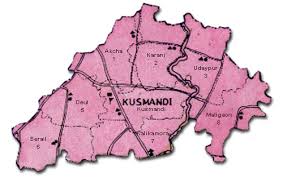
| District Map |

How Many Subdivisions/Blocks in DDinajpur ?
Sub-Divisions : 2 (two)
1. Balurghat (Sadar) Sub-Division.
2.Gangarampur at Buniadpur.
Blocks : 8 (Eight)
1.Balurghat
2.Hili
3.Kumarganj
4.Tapan
5.Gangarampur
6.Kushmandi
7.Banshihari
8.Harirampur
How Many Population District in Dakshin Dinajpur?
1.Male : 770335
2.Female : 732843
TOTAL = 15,03,178
[SC 28.78% and S.T. 16.12%]
Block-wise
1.Balurghat : 2,28,736
2.Hili : 77,250
3.Kumarganj : 1,53,042
4.Tapan : 2,26,136
5.Gangarampur: : 2,05,540
6.Banshihari : 1,22,091
7.Kushmandi : 1,75,086
8. Harirampur : 1,24,927
Municipality-wise
1.Balurghat Municipality : 1,35,7372.Gangarampur Municipality : 53,533
Educational details:
Literacy : 64.50% [Male 75.30% Female 55.10%]
SC: Male 45.72%, Female 10.06%
ST: Male 24.42% Female 9.10%
Schools/Colleges:
1. No. of primary School : 1190
2.No. of SSK : 531
3.No. of MSK : 39
4.No. of Jr. High School : 03
5.No. of High School : 82
6.No. of Higher Secondary School : 64
7.No. of senior Madrasa : 12
8.No. of Junior Madrasa : 04
9.No of College : 04
10.No. of B-Ed College : 01
11.No. of Law College : 01
12.No. of ITI : 01
13.No. of NCLP School : 40
14.No. of CEC : 532
14.No. of NCEC : 39
15.No. of public Library : 65
Rivers and Streams
2.Tangon,
3.Punarbhava,
5.Ichamati,
6.Brahmani.


